

October 12, 2026 morning edition. Official sources checked starting Oct 12, 4:08 AM PDT. Advisory points rechecked Oct 12, 4:32 AM PDT. Each product retains its own issue and observation time.
01 · Weather ahead · October 12, 2026
KirkwoodMtn: colder air and light mountain snow chances.
Monday, October 12, 2026 · Morning edition · official sources checked starting at 4:08 AM PDT.
¡Buenos días my friends,
Cup’ ☕️’ Joe in hand, #StokeLevel @12.7, here’s what’s on-tap for the day ahead…
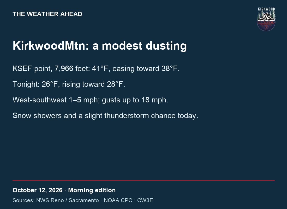
At KSEF’s 7,966-foot mountain point, Monday reaches 41°F before easing toward 38°F. Tonight falls to 26°F before rising toward 28°F. Snow showers and a slight thunderstorm chance develop today, with a 60% precipitation chance. West-southwest winds of 1–5 mph gust to 18 mph. Tonight’s northeast gusts can reach 33 mph. The separate 8,268-foot regional grid reaches 38°F.
Forecast edition, observations & live views
Forecast edition: Monday, October 12, 2026 · Morning edition · official sources checked starting at 4:08 AM PDT.. One daily edition starts at 4 a.m. Pacific; completion time varies.
Observations: station and lake measurements keep their individual source times. Previous-day readings are snapshots.
Live views: radar, lake feeds and cameras can update independently. A new page revision time does not refresh an older forecast or reading.
Explore Tahoe by place & elevation
Orientation sketch, not to scale. Select a point to update its forecast and seven-day view. The 7,966-foot and 8,268-foot points are distinct locations; neither represents every elevation on the mountain.
DAY & NIGHT FORECAST
Pick a place. Follow the weather.
Choose a day or night to compare temperature, wind and forecast snow. Times are Pacific.
Kirkwood mountain point · 7,966 ft · Mon 10/12 Daytime
A slight chance of snow before 11am, then a chance of snow showers and a slight chance of thunderstorms between 11am and 2pm, then showers and thunderstorms likely between 2pm and 5pm, then a chance of snow
Temperature · °F
Read the full source tables below for every forecast period.
Compare locations for this period
Official NWS mountain point west of Carson Pass. Updated Oct 12, 2:00 AM PDT. Daytime and following overnight periods start Monday morning; the preceding overnight is excluded.
NWS mountain point west of Carson Pass. Snow amount is unavailable for this point in this edition; the 8,268-foot grid is a separate forecast.
Read the official forecast ↗THE WEEK AT A GLANCE
Follow the next change.
Kirkwood mountain point · 7,966 ft
Mon Oct 12
41° / 26°Slight Chance Light Snow then Chance Snow Showers Day: WSW 1 to 5 mph Night: NE 1 to 8 mph
Tue Oct 13
51° / 32°Widespread Frost then Sunny Day: ENE 2 to 9 mph Night: ENE 2 to 7 mph
Wed Oct 14
59° / 38°Sunny Day: NE 2 to 7 mph Night: ENE 2 to 15 mph
Thu Oct 15
60° / 39°Sunny Day: ENE 5 to 15 mph Night: ENE 5 to 16 mph
Fri Oct 16
67° / 42°Sunny Day: NE 2 to 16 mph Night: ENE 3 mph
Sat Oct 17
64° / 41°Sunny Day: SSW 3 mph Night: SE 3 mph
Sun Oct 18
61° / —/ unavailable Sunny Day: SSW 5 mph Night: unavailable
Daytime high / overnight low, °F. Select a place above to compare the week ahead. Unavailable overnight forecasts are labeled.
Full forecast text · today & tonight
Monday · October 12
Official point forecasts. The 7,966-foot KSEF mountain point and 8,268-foot regional grid are separate locations.
KSEF mountain point
7,966 ft · NWS forecast point
Columbus Day: A slight chance of snow before 11am, then a chance of snow showers and a slight chance of thunderstorms between 11am and 2pm, then showers and thunderstorms likely between 2pm and 5pm, then a chance of snow. Partly sunny. High near 41, with temperatures falling to around 38 in the afternoon. West southwest wind 1 to 5 mph, with gusts as high as 18 mph. Chance of precipitation is 60%. Little or no snow accumulation expected.
Monday Night: A chance of snow before 11pm, then widespread frost. Partly cloudy. Low around 26, with temperatures rising to around 28 overnight. Northeast wind 1 to 8 mph, with gusts as high as 33 mph. Chance of precipitation is 50%. New rainfall amounts less than a tenth of an inch possible.
Issued Oct 12, 2:00 AM PDT.
Official NWS forecast ↗South Lake Tahoe
6,293 ft · NWS forecast point
Columbus Day: A chance of rain and snow showers. Partly sunny, with a high near 44. West wind 0 to 5 mph. Chance of precipitation is 50%.
Monday Night: A chance of rain and snow showers before 11pm. Partly cloudy, with a low around 25. Northeast wind 0 to 5 mph. Chance of precipitation is 50%.
Issued Oct 11, 11:30 PM PDT.
Official NWS forecast ↗KirkwoodMtn regional grid
8,268 ft · NWS forecast point
Columbus Day: A slight chance of snow before 11am, then snow showers likely and a slight chance of thunderstorms between 11am and 5pm, then a chance of snow. Partly sunny. High near 38, with temperatures falling to around 35 in the afternoon. West southwest wind around 6 mph, with gusts as high as 18 mph. Chance of precipitation is 60%. New snow accumulation of less than half an inch possible.
Monday Night: A chance of snow before 11pm, then widespread frost between 11pm and 4am. Partly cloudy, with a low around 26. North northeast wind 2 to 14 mph, with gusts as high as 37 mph. Chance of precipitation is 50%. Little or no snow accumulation expected.
Issued Oct 12, 2:00 AM PDT.
Official NWS forecast ↗Olympic Valley
6,283 ft · NWS forecast point
Columbus Day: A slight chance of thunderstorms and a chance of rain and snow showers after 2pm. Mostly sunny, with a high near 48. West wind 0 to 5 mph. Chance of precipitation is 40%.
Monday Night: A chance of rain and snow showers before 11pm. Mostly clear, with a low around 22. North wind around 5 mph. Chance of precipitation is 30%.
Issued Oct 11, 11:30 PM PDT.
Official NWS forecast ↗Kirkwood seven-day forecast · full text
KirkwoodMtn October 12 to October 18 · 7,966-foot point
Official NWS mountain point west of Carson Pass. Updated Oct 12, 2:00 AM PDT. Daytime and following overnight periods start Monday morning; the preceding overnight is excluded.
Columbus Day
A slight chance of snow before 11am, then a chance of snow showers and a slight chance of thunderstorms between 11am and 2pm, then showers and thunderstorms likely between 2pm and 5pm, then a chance of snow. Partly sunny. High near 41, with temperatures falling to around 38 in the afternoon. West southwest wind 1 to 5 mph, with gusts as high as 18 mph. Chance of precipitation is 60%. Little or no snow accumulation expected.
Monday Night
A chance of snow before 11pm, then widespread frost. Partly cloudy. Low around 26, with temperatures rising to around 28 overnight. Northeast wind 1 to 8 mph, with gusts as high as 33 mph. Chance of precipitation is 50%. New rainfall amounts less than a tenth of an inch possible.
Tuesday
Widespread frost before 8am. Sunny, with a high near 51. East northeast wind 2 to 9 mph, with gusts as high as 36 mph.
Tuesday Night
Clear, with a low around 32. East northeast wind 2 to 7 mph, with gusts as high as 31 mph.
Wednesday
Sunny, with a high near 59.
Wednesday Night
Clear, with a low around 38.
Thursday
Sunny, with a high near 60.
Thursday Night
Clear, with a low around 39.
Friday
Sunny, with a high near 67.
Friday Night
Clear, with a low around 42.
Saturday
Sunny, with a high near 64.
Saturday Night
Clear, with a low around 41.
Sunday
Sunny, with a high near 61.
Seven-day regional comparison · full table
October 12 to October 18 · Seven days, day and night
| Day | KSEF mountain point · 7,966 ft | South Lake Tahoe · 6,293 ft | KirkwoodMtn regional grid · 8,268 ft | Olympic Valley · 6,283 ft |
|---|---|---|---|---|
| Mon Oct 12 | 41° / 26°Slight Chance Light Snow then Chance Snow ShowersDay: WSW 1 to 5 mphNight: NE 1 to 8 mph | 44° / 25°Chance Rain And Snow ShowersDay: W 0 to 5 mphNight: NE 0 to 5 mph | 38° / 26°Slight Chance Light Snow then Snow Showers LikelyDay: WSW 6 mphNight: NNE 2 to 14 mph | 48° / 22°Mostly Sunny then Slight Chance T-stormsDay: W 0 to 5 mphNight: N 5 mph |
| Tue Oct 13 | 51° / 32°Widespread Frost then SunnyDay: ENE 2 to 9 mphNight: ENE 2 to 7 mph | 49° / 32°SunnyDay: E 0 to 5 mphNight: E 0 to 5 mph | 48° / 32°SunnyDay: ENE 3 to 14 mphNight: ENE 3 to 13 mph | 56° / 28°SunnyDay: NE 0 to 5 mphNight: E 0 to 5 mph |
| Wed Oct 14 | 59° / 38°SunnyDay: NE 2 to 7 mphNight: ENE 2 to 15 mph | 58° / 37°SunnyDay: E 0 to 5 mphNight: E 0 to 5 mph | 56° / 39°SunnyDay: NE 3 to 12 mphNight: ENE 3 to 20 mph | 64° / 34°SunnyDay: E 0 to 5 mphNight: NE 0 to 15 mph |
| Thu Oct 15 | 60° / 39°SunnyDay: ENE 5 to 15 mphNight: ENE 5 to 16 mph | 59° / 37°SunnyDay: E 5 to 10 mphNight: E 5 to 10 mph | 57° / 39°SunnyDay: ENE 5 to 20 mphNight: ENE 5 to 20 mph | 65° / 34°SunnyDay: E 5 to 15 mphNight: E 5 to 15 mph |
| Fri Oct 16 | 67° / 42°SunnyDay: NE 2 to 16 mphNight: ENE 3 mph | 64° / 42°SunnyDay: NE 0 to 5 mphNight: 0 mph | 64° / 42°SunnyDay: NE 2 to 18 mphNight: ENE 2 to 6 mph | 69° / 35°SunnyDay: E 0 to 15 mphNight: E 0 to 5 mph |
| Sat Oct 17 | 64° / 41°SunnyDay: SSW 3 mphNight: SE 3 mph | 65° / 42°SunnyDay: 0 mphNight: 0 mph | 60° / 41°SunnyDay: N 5 mphNight: SE 2 to 6 mph | 69° / 35°SunnyDay: 0 mphNight: 0 mph |
| Sun Oct 18 | 61° / unavailableSunnyDay: SSW 5 mphNight: unavailable | 64° / unavailableSunnyDay: SW 0 to 5 mphNight: unavailable | 58° / unavailableSunnyDay: SSW 3 to 7 mphNight: unavailable | 66° / unavailableSunnyDay: SW 0 to 5 mphNight: unavailable |
Point issue times: KSEF mountain point Oct 12, 2:00 AM PDT; South Lake Tahoe Oct 11, 11:30 PM PDT; KirkwoodMtn regional grid Oct 12, 2:00 AM PDT; Olympic Valley Oct 11, 11:30 PM PDT. Missing periods remain unavailable.
YOUR MOUNTAIN, IN VIEW
Look toward the Kirkwood ridgeline.
KirkwoodMtn · Cornice Cam. Compare the sky and mountain view with the forecast above.
Resort camera feed. Read the camera’s own timestamp; its clock is separate from the morning forecast. A frozen or unavailable feed is not a current observation.
Explore all five resort cameras ↗Camera loads when selected.
Observed weather · NOAA / National Weather Service
Live NEXRAD radar · Tahoe & the Sierra
Recent radar reflectivity from NOAA’s regional composite. The map keeps NOAA’s colors and reports the actual observation time.
Observation time loading.
NOAA radar loads when this section comes into view. It checks for new observations every five minutes while visible.
Source: NOAA NWS / MRMS, using the NEXRAD network. Observation age and feed availability are shown above. Reflectivity is different from measured snowfall. State boundaries: NWS. Place labels are geographic references.
Official forecast sources
KirkwoodMtn forecast desk
The linked Kirkwood point is 5 miles west of Carson Pass, about 7,966 ft. Owens Camp (OWNC1), shown as current conditions on that NWS page, is a separate 5,240-foot observation station. Neither replaces the higher-elevation KirkwoodMtn instruments below.
Coop’s mountain perspective
Coop’s mountain read · October 12
Colder showers today. A modest high Sierra dusting remains in play.
StokeLevel @12.7, my friends. Ole Neptune has a chilly wave on deck, but #NoOverStoking: this is a modest dusting watch. Showers pick up this afternoon, with a slight thunderstorm chance along the crest. Most moisture moves out before the coldest air settles in tonight. KirkwoodMtn and the high passes can catch a little white; Tahoe lake level is looking at little or no accumulation. Keep an eye on MammothMtn and Mono County, where lingering showers could meet the colder air later. Stay tuned and thirsty. The 26/27 PowHunt’n season is around the bend.
NWS Reno’s October 12, 12:58 AM PDT discussion has reduced snowfall potential since Sunday. Through Tuesday morning, it calls for a dusting to less than one inch at Donner, Echo and Spooner summits, around one inch at Carson Pass, Mount Rose Highway summit and Tioga Pass, and around two inches at Sonora Pass. These are regional pass forecasts, not resort snow reports. Most showers end before the coldest air arrives. Snow levels near 6,000–7,500 feet today fall below 6,000 feet around 8–11 PM in Tahoe, reaching roughly 4,000 feet near Truckee and 5,500 feet near Mammoth by daybreak Tuesday. Sacramento’s October 11, 1:39 PM PDT discussion favors the first measurable Sierra snow mainly south of US50 and above 6,500 feet. It keeps mountain showers and isolated thunderstorms in Monday’s forecast. Drying and gradual warming return from Tuesday.
#StokeLevel @12.7 is personal enthusiasm, separate from forecast confidence.
Big Blue, year round
Lake Tahoe water, waves & level
Lake feeds refresh independently when available. Forecast issue time, buoy observation time and USGS measurement time are different.
Sources checked Oct 12, 4:08 AM PDT. NWS Reno discussion issued Oct 12, 12:58 AM PDT; Sacramento discussion issued Oct 11, 1:39 PM PDT. Each forecast and observation retains its own issue or reading time.
Mid-lake water temperature
60.5°F
NWS bulletin’s buoy reportWave forecast · see issue time
Less than 1 foot today and tonight
Mid-lake waters and downwind shoresLake level at Tahoe City
6226.77 ft
USGS · U.S. Bureau of Reclamation datumChange from the prior day
-0.04 ft
Same station, same Pacific clock timeNWS Reno recreation forecast issued October 12 at 2:32 AM PDT. Water temperature observation time is not specified.
Sources checked Oct 12, 4:08 AM PDT. NWS Reno discussion issued Oct 12, 12:58 AM PDT; Sacramento discussion issued Oct 11, 1:39 PM PDT. Each forecast and observation retains its own issue or reading time.
USGS Oct 12, 4:00 AM PDT · provisional. Elevation is 6,220 ft plus gage height in the USBR datum; change compares the same Pacific clock time one day earlier.
October 12 NWS recreation bulletin · original source text
Relative time words in this official bulletin refer to October 11, 2026. The NWS bulletin level is separate from the USGS measurement.
Lake Tahoe at Lake Level-232 AM PDT Mon Oct 12 2026

.TODAY...Mostly cloudy. Chance of showers in the morning, then
chance of showers and thunderstorms in the afternoon. Light winds.
Highs 43 to 49. Wave Heights less than 1 foot.
.TONIGHT...Mostly cloudy with a chance of showers in the evening,
then clear after midnight. North winds around 10 mph. Lows 24 to 29.
Wave Heights less than 1 foot.
.TUESDAY...Sunny. East winds around 10 mph  in the morning becoming
light. Highs 48 to 54. Wave Heights less than 1 foot.

Water Temperature at the Mid Lake Buoys......60.5 degrees.
Lake Level for Lake Tahoe at Tahoe City......6228.29 feet.
Official NWS source ↗
Lake wind timeline · Windfinder
Wind direction & local weather
Wind & weather at Sandy Way
South Lake Tahoe / Sandy Way: wind, gusts and the next two days.

Reference graphic from September 25. Current Windfinder guidance appears in the live two-day forecast below, with its own provider times.
Reference graphic from September 25. Current Windfinder guidance appears in the live two-day forecast below, with its own provider times.
Two-day Windfinder forecast
Swipe across to see all hours. Source: Windfinder. Wind: knots · Temperature: °F · Rain: inches · Pressure: hPa · Waves, when available: feet.
Open Windfinder · S Lake Tahoe / Sandy Way ↗
Wind direction: SW means wind from the southwest, blowing toward the northeast.
Units: Windfinder uses knots. One knot is about 1.15 mph; the NAM gust charts below use mph. Source: Windfinder.
Caltrans · Tahoe roads & conditions
Checked Oct 12, 2026 · 0408 PDT · refreshed with the daily editions
SR88
Silver Lake → Carson Spur / Carson Pass → Woodfords
No traffic restrictions are reported for this area.
This highway information is the latest reported as of Monday, October 12th, 2026 at 04:08 AM.Hwy50
Pollock Pines → Kyburz / Echo Summit → South Lake Tahoe
No Caltrans notice identified within this corridor.
This highway information is the latest reported as of Monday, October 12th, 2026 at 04:08 AM.I80
Emigrant Gap / Nyack → Donner Summit → Truckee / Nevada line
All westbound trucks are required to stop at the brake check area 0.5 mi west of Nyack (Placer Co) - To reduced the risk of brake fires
This highway information is the latest reported as of Monday, October 12th, 2026 at 04:08 AM.Closures and chain controls: use the Caltrans links above for the latest reports.
Model guidance · precipitation, wind & temperature
WeatherBell Analytics · NAM 3km · US States › California
Forecast model guidance
The local forecast context
Showers increase Monday afternoon, then diminish tonight. Most moisture ends before the coldest air arrives. Regional pass snowfall remains modest; Tahoe lake level has little or no accumulation forecast. Drying and gradual warming follow Tuesday.
Compare the maps by location, valid time and units. The local point forecast remains the guide for your part of the mountain.
Start with the point forecasts above, then compare precipitation, wind and temperature. These are forecasts; the live NOAA radar shows observations.
New guidance initialized Oct 11 · 11:00 PM PDT. Each map states its actual valid period and units.
Precipitation · Guidance / Models · 4 views
Liquid precipitation and snowfall use different quantities. Use the separately labeled point snow forecast for local amounts.
MSLP · 6-hour precipitation · T850
Precipitation in inches · pressure hPa · temperature °C


A six-hour liquid-precipitation window with surface pressure and temperature at 850mb. The current native export uses inches; 1 inch = 25.4 mm.
Valid Oct 12 · 5:00 AM PDT through Oct 14 · 11:00 AM PDT. 55 distinct forecast frames. Source: WeatherBell / NOAA NCEP.
First, middle & last forecast frames · PNG
 First · Oct 12 · 5:00 AM PDT ↗
 Last · Oct 14 · 11:00 AM PDT ↗
Reflectivity Type
Reflectivity dBZ · precipitation type

Modeled radar echoes and precipitation type. Compare timing with the observed NOAA radar above.
Valid Oct 11 · 11:00 PM PDT through Oct 14 · 11:00 AM PDT. 61 distinct forecast frames. Source: WeatherBell / NOAA NCEP.
First, middle & last forecast frames · PNG
 First · Oct 11 · 11:00 PM PDT ↗
 Last · Oct 14 · 11:00 AM PDT ↗
Precipitation total
Liquid precipitation · inches

Accumulated liquid precipitation since initialization, through the valid time on each frame. This is not a snowfall total.
Valid Oct 12 · 12:00 AM PDT through Oct 14 · 11:00 AM PDT. 60 distinct forecast frames. Source: WeatherBell / NOAA NCEP.
First, middle & last forecast frames · PNG
 First · Oct 12 · 12:00 AM PDT ↗
 Last · Oct 14 · 11:00 AM PDT ↗
Precipitation total · 24 hours
Rolling 24-hour liquid precipitation · inches

Precipitation during the 24 hours ending at each frame’s valid time. These overlapping windows must not be added together.
Valid Oct 12 · 11:00 PM PDT through Oct 14 · 11:00 AM PDT. 37 distinct forecast frames. Source: WeatherBell / NOAA NCEP.
First, middle & last forecast frames · PNG
 First · Oct 12 · 11:00 PM PDT ↗
 Last · Oct 14 · 11:00 AM PDT ↗
Wind · Guidance / Models · 5 views
Separate sustained wind, gusts and accumulated maximum gusts. Model wind and station observations have different times and locations.
0–6 km wind shear
Wind-vector difference · knots

Change in the wind vector between the surface and 6 km. The native map is labeled knots; WeatherBell’s menu lists m/s². We retain the map’s actual units. 1 knot = 0.514444 m/s.
Valid Oct 11 · 11:00 PM PDT through Oct 14 · 11:00 AM PDT. 61 distinct forecast frames. Source: WeatherBell / NOAA NCEP.
First, middle & last forecast frames · PNG
 First · Oct 11 · 11:00 PM PDT ↗
 Last · Oct 14 · 11:00 AM PDT ↗
10m wind gust
Gust speed · mph

Forecast gust magnitude near the surface. Gust speed alone does not establish wind direction.
Valid Oct 12 · 12:00 AM PDT through Oct 14 · 11:00 AM PDT. 60 distinct forecast frames. Source: WeatherBell / NOAA NCEP.
First, middle & last forecast frames · PNG
 First · Oct 12 · 12:00 AM PDT ↗
 Last · Oct 14 · 11:00 AM PDT ↗
10m wind speed
Wind speed and streamlines · mph
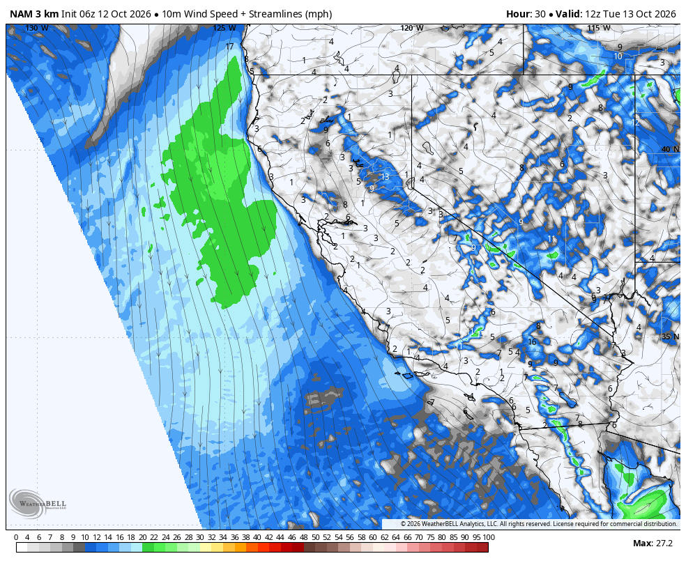
Near-surface wind speed and modeled flow. Exposed ridges and sheltered terrain can differ.
Valid Oct 11 · 11:00 PM PDT through Oct 14 · 11:00 AM PDT. 61 distinct forecast frames. Source: WeatherBell / NOAA NCEP.
First, middle & last forecast frames · PNG
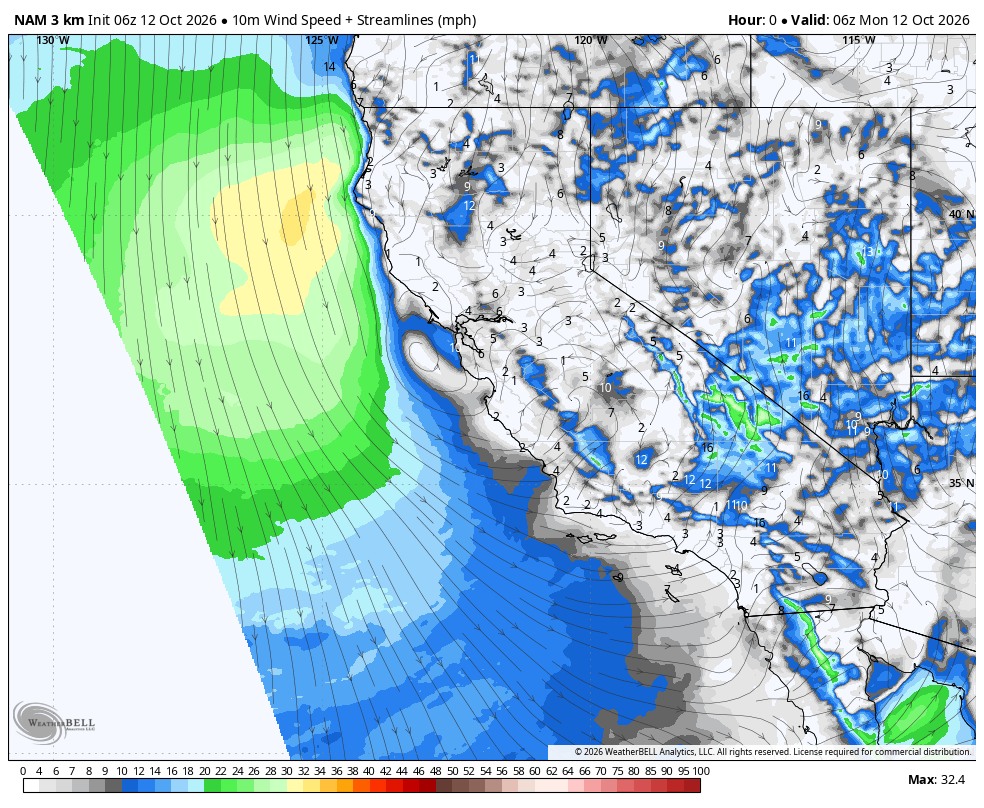 First · Oct 11 · 11:00 PM PDT ↗
 Last · Oct 14 · 11:00 AM PDT ↗
10m wind gust swath
Accumulated maximum gust · mph
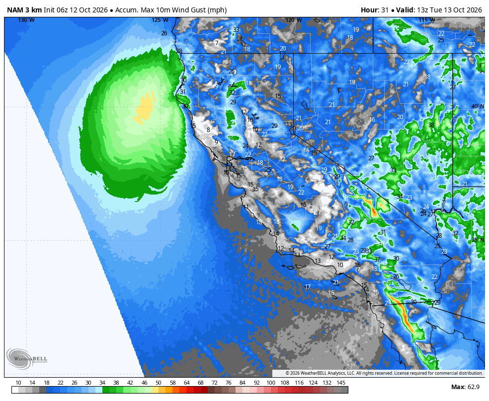
Highest forecast gust reached since initialization, through each valid time. This is not the wind at a single instant.
Valid Oct 12 · 12:00 AM PDT through Oct 14 · 11:00 AM PDT. 60 distinct forecast frames. Source: WeatherBell / NOAA NCEP.
First, middle & last forecast frames · PNG
 First · Oct 12 · 12:00 AM PDT ↗
 Last · Oct 14 · 11:00 AM PDT ↗
925mb wind speed · MSLP
Wind knots · sea-level pressure hPa

Flow at the 925mb pressure level, with sea-level pressure. This level can lie below Sierra terrain; it is not a summit-wind forecast.
Valid Oct 11 · 11:00 PM PDT through Oct 14 · 11:00 AM PDT. 61 distinct forecast frames. Source: WeatherBell / NOAA NCEP.
First, middle & last forecast frames · PNG
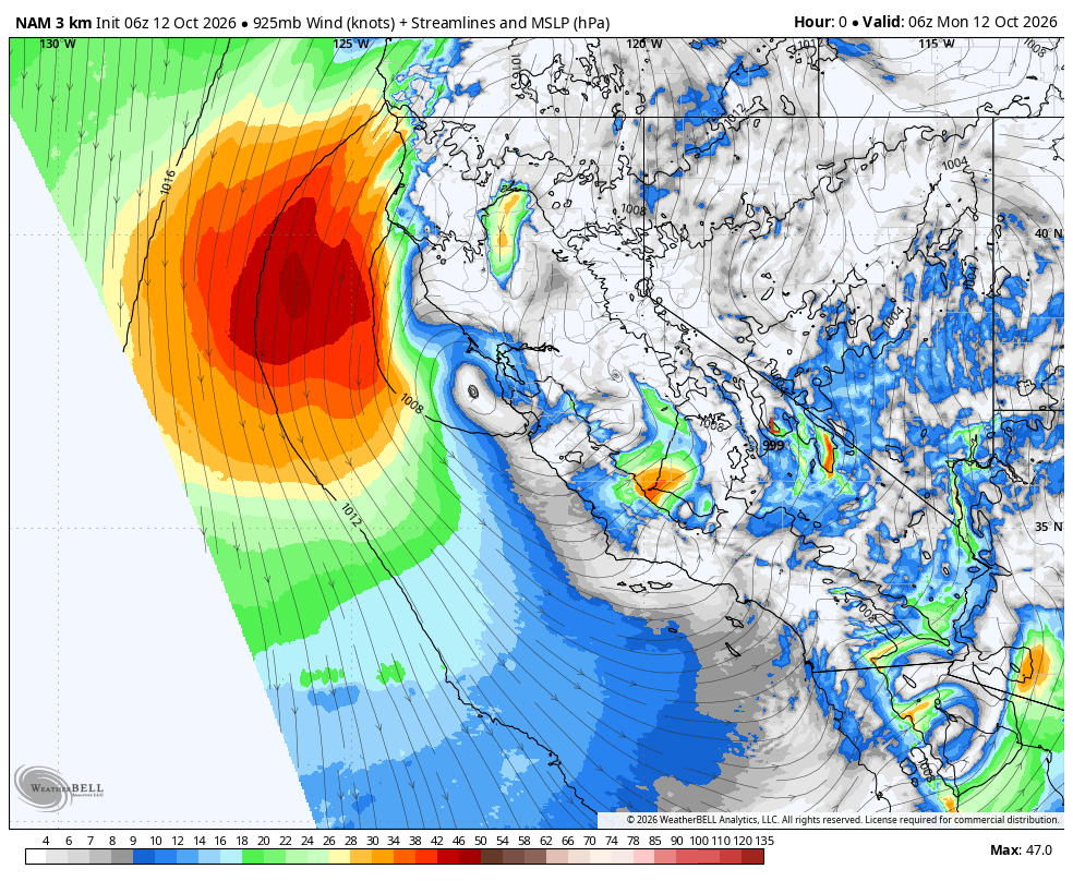 First · Oct 11 · 11:00 PM PDT ↗
 Last · Oct 14 · 11:00 AM PDT ↗
Temperature · Guidance / Models · 3 views
Rolling maximum/minimum maps cover the preceding 24 hours. A temperature-change map is a difference, not the forecast temperature.
2m temperature · 24-hour maximum
Rolling 24-hour maximum · °F
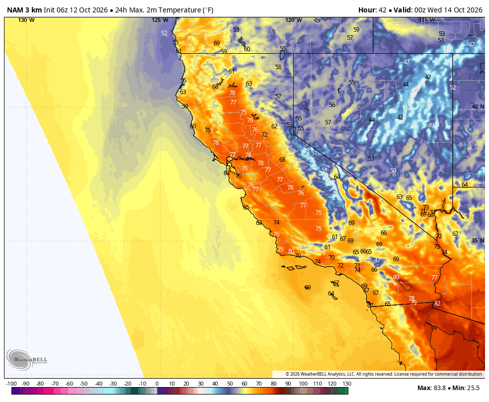
Highest near-surface temperature in the preceding 24 hours.
Valid Oct 12 · 11:00 PM PDT through Oct 14 · 11:00 AM PDT. 7 distinct forecast frames. Source: WeatherBell / NOAA NCEP.
First, middle & last forecast frames · PNG
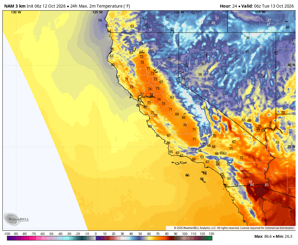 First · Oct 12 · 11:00 PM PDT ↗
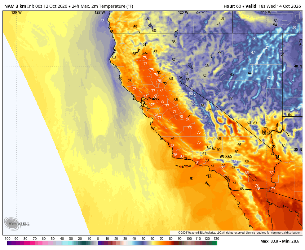 Last · Oct 14 · 11:00 AM PDT ↗
2m temperature · 24-hour minimum
Rolling 24-hour minimum · °F

Lowest near-surface temperature in the preceding 24 hours.
Valid Oct 12 · 11:00 PM PDT through Oct 14 · 11:00 AM PDT. 7 distinct forecast frames. Source: WeatherBell / NOAA NCEP.
First, middle & last forecast frames · PNG
 First · Oct 12 · 11:00 PM PDT ↗
 Last · Oct 14 · 11:00 AM PDT ↗
2m temperature · 24-hour change
Temperature difference · °F
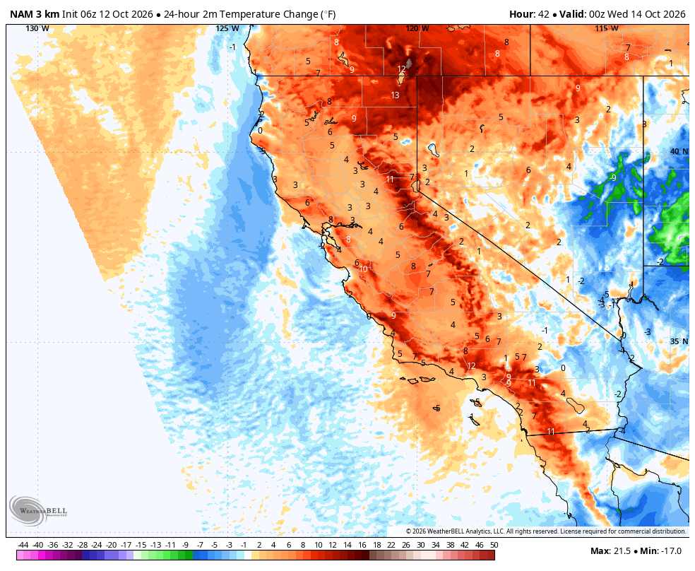
Change from the same valid hour one day earlier. Positive values mean warmer; negative values mean colder.
Valid Oct 12 · 11:00 PM PDT through Oct 14 · 11:00 AM PDT. 37 distinct forecast frames. Source: WeatherBell / NOAA NCEP.
First, middle & last forecast frames · PNG
 First · Oct 12 · 11:00 PM PDT ↗
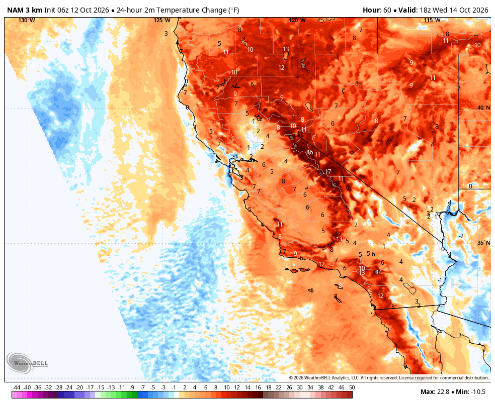 Last · Oct 14 · 11:00 AM PDT ↗
Additional NAM views · six-hour precipitation & temperature
NAM 3km six-hour precipitation
Liquid precipitation · inches
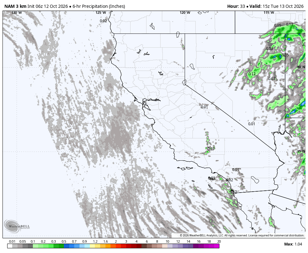
Initialized Oct 11, 11:00 PM PDT. Valid Oct 12, 5:00 AM PDT through Oct 14, 11:00 AM PDT. 55 forecast frames. Source: WeatherBell.
First, middle & last source frames
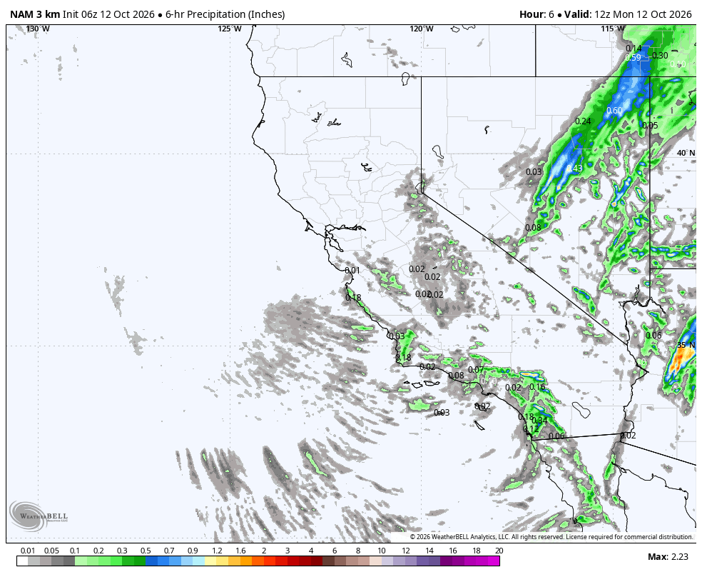 First · Oct 12, 5:00 AM PDT ↗
 Last · Oct 14, 11:00 AM PDT ↗
NAM 3km California temperature
2m air temperature · °F
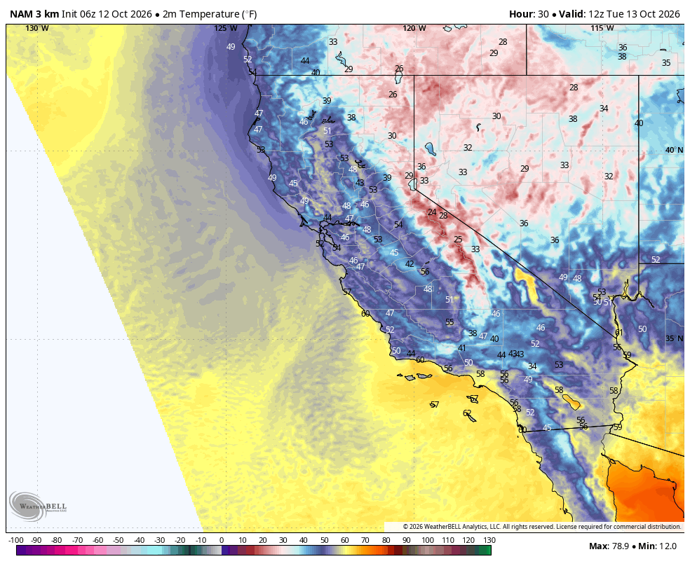
Initialized Oct 11, 11:00 PM PDT. Valid Oct 11, 11:00 PM PDT through Oct 14, 11:00 AM PDT. 61 forecast frames. Source: WeatherBell.
First, middle & last source frames
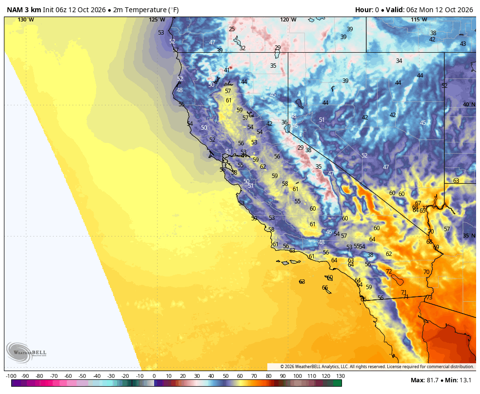 First · Oct 11, 11:00 PM PDT ↗
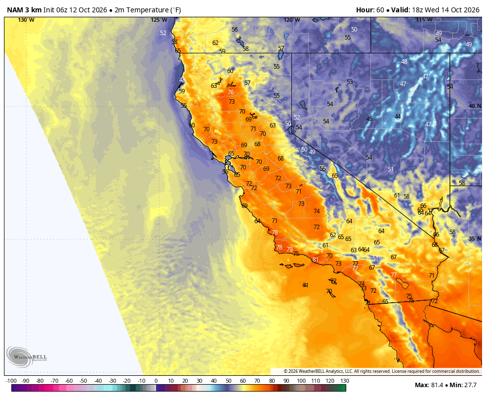 Last · Oct 14, 11:00 AM PDT ↗
Sources checked Oct 12, 4:08 AM PDT. NWS Reno discussion issued Oct 12, 12:58 AM PDT; Sacramento discussion issued Oct 11, 1:39 PM PDT. Each forecast and observation retains its own issue or reading time.
Reno forecast discussion ↗ · Sacramento forecast discussion ↗
Forecast: NWS · Maps: WeatherBell / NOAA.
GOES-West · California observations
Infrared satellite observations, not a forecast or seasonal diagnosis.
GOES-West [CONUS] 0.02° · California
ABI Channel 13 brightness temperature · °C
![GOES-West [CONUS] 0.02° · California · Observed Oct 11, 6:38 PM PDT through Oct 12, 2:58 AM PDT.](https://images.squarespace-cdn.com/content/6627bd7c18b72448db6dc807/d7b00dce-3d7c-4e46-bdd8-b048c47f4bf4/goes_west_20261012_Middle.png?content-type=image%2Fpng)
Observed Oct 11, 6:38 PM PDT through Oct 12, 2:58 AM PDT. 35 source frames. Source: WeatherBell.
First, middle & last source frames
![GOES-West [CONUS] 0.02° · California · First · Oct 11, 6:38 PM PDT](https://images.squarespace-cdn.com/content/6627bd7c18b72448db6dc807/701d4f2d-3e55-4d4c-8e8a-868adf4c9b9d/goes_west_20261012_First.png?content-type=image%2Fpng) First · Oct 11, 6:38 PM PDT ↗
First · Oct 11, 6:38 PM PDT ↗![GOES-West [CONUS] 0.02° · California · Last · Oct 12, 2:58 AM PDT](https://images.squarespace-cdn.com/content/6627bd7c18b72448db6dc807/a19d9553-d787-487b-9110-b26aa1d01933/goes_west_20261012_Last.png?content-type=image%2Fpng) Last · Oct 12, 2:58 AM PDT ↗
Last · Oct 12, 2:58 AM PDT ↗GFS guidance · Continental United States
Deterministic GFS precipitation type/rate and simulated reflectivity. Source: Pivotal Weather / NOAA NCEP. Model guidance is not an observation.
GFS precipitation type and rate
Liquid-equivalent precipitation rate · inches/hour

Initialized Oct 11, 11:00 PM PDT. Valid Oct 12, 5:00 AM PDT through Oct 27, 11:00 PM PDT. 64 source frames. Source: Pivotal Weather · GFS / NOAA.
First, middle & last source frames
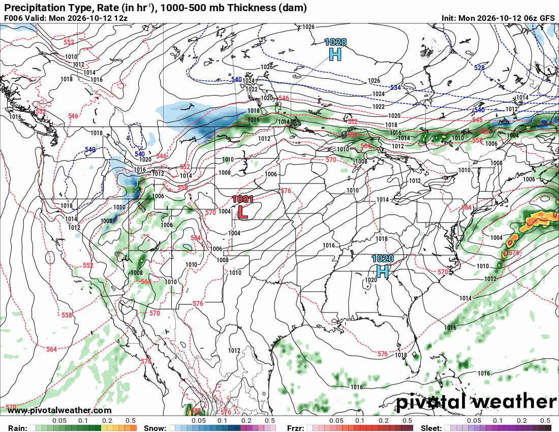 First · Oct 12, 5:00 AM PDT ↗
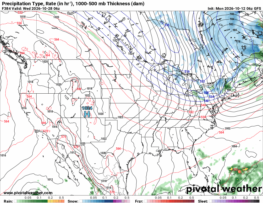 Last · Oct 27, 11:00 PM PDT ↗
GFS composite reflectivity
Simulated radar reflectivity · dBZ
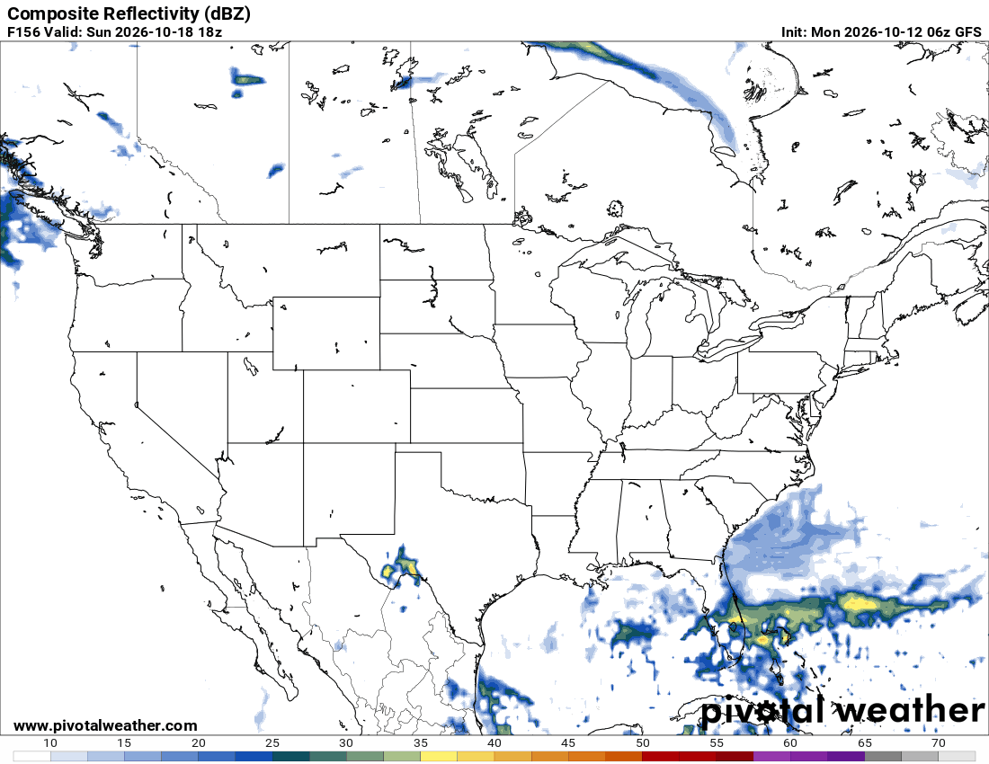
Initialized Oct 11, 11:00 PM PDT. Valid Oct 11, 11:00 PM PDT through Oct 27, 11:00 PM PDT. 105 source frames. Source: Pivotal Weather · GFS / NOAA.
First, middle & last source frames
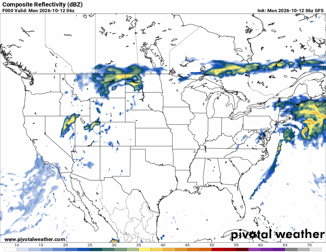 First · Oct 11, 11:00 PM PDT ↗
 Last · Oct 27, 11:00 PM PDT ↗
October 12 forecast briefing
These summary slides complement the scientific maps and retain the source issue dates.


02 · Winter 2026/27
Snow, resorts & first turns.
First chair dates. Fresh snow. The season tally. Frothy for #PowHunt’n Season.
Thanksgiving 2026 · Coop’s season kickoff
Coop’s kickoff date; resort opening dates may differ.
Storm watch & snow language
Winter 2026/27 · Sierra storm watch
Cold air. Moisture. Mountain life.
From the Sierra Crest to Tahoe and MammothMtn, we’re watching where the moisture lands, when the cold air arrives and how the snow stacks up. Skiers, riders, SledNecks and backcountry friends, this is our winter weather desk.
Monday showers, then chilly overnight air
Afternoon showers bring modest high-elevation snow chances. Most moisture ends before the coldest air arrives tonight; drying and warming follow Tuesday.
We watch the Pacific storm track, the moisture tap and the cold air together. An atmospheric river alone does not establish powder conditions.
Base building to #ColdSmokePow
October through December 24, base-building storms get the season started. Once the base is established, colder storms and lighter snow are the prize.
Coop’s snow language: about 10:1 is #SchmooPow; 15:1 and higher is #ColdSmokePow. Wet, dense snow earns #BaseBuilder, #SierraCement or #GorillaSnot when the conditions fit.
A 10:1 model map uses a fixed conversion: one inch of liquid to ten inches of snow. It does not predict a 15:1 powder ratio. Snow ratios describe water content, not avalanche danger or terrain readiness.
We’ll raise the stoke when the cold air, moisture and timing come together. For now, keep an eye on the dated forecast above.
Day & night snowfall · full source tables
Forecast snow · daytime vs overnight
Snow timing, wind & temperatures
Daytime is 6 a.m.–6 p.m.; overnight is 6 p.m.–6 a.m. the following day, Pacific time. Snow values below are the NWS point forecasts for those exact periods. They are separate from recent measured snowfall.
Kirkwood mountain point · 8,268 ft
| Period · Pacific | Forecast snow | High / low | Wind | Sky / weather |
|---|---|---|---|---|
| Mon 10/12 Daytime | Unavailable | 38°F | WSW 6 mph | Slight Chance Light Snow then Snow Showers Likely |
| Mon 10/12 Overnight | Unavailable | 26°F | NNE 2 to 14 mph | Chance Light Snow then Widespread Frost |
| Tue 10/13 Daytime | 0 in | 48°F | ENE 3 to 14 mph | Sunny |
| Tue 10/13 Overnight | 0 in | 32°F | ENE 3 to 13 mph | Clear |
| Wed 10/14 Daytime | 0 in | 56°F | NE 3 to 12 mph | Sunny |
| Wed 10/14 Overnight | 0 in | 39°F | ENE 3 to 20 mph | Clear |
NWS grid updated Oct 12 · 2:00 AM PDT. Official point data ↗
Compare the other Tahoe forecast points
South Lake Tahoe
| Period · Pacific | Forecast snow | High / low | Wind | Sky / weather |
|---|---|---|---|---|
| Mon 10/12 Daytime | 0 in | 44°F | W 0 to 5 mph | Chance Rain And Snow Showers |
| Mon 10/12 Overnight | 0 in | 25°F | NE 0 to 5 mph | Chance Rain And Snow Showers then Partly Cloudy |
| Tue 10/13 Daytime | 0 in | 49°F | E 0 to 5 mph | Sunny |
| Tue 10/13 Overnight | 0 in | 32°F | E 0 to 5 mph | Clear |
| Wed 10/14 Daytime | 0 in | 58°F | E 0 to 5 mph | Sunny |
| Wed 10/14 Overnight | 0 in | 37°F | E 0 to 5 mph | Clear |
NWS grid updated Oct 11 · 11:30 PM PDT. Official point data ↗
Olympic Valley
| Period · Pacific | Forecast snow | High / low | Wind | Sky / weather |
|---|---|---|---|---|
| Mon 10/12 Daytime | 0 in | 48°F | W 0 to 5 mph | Mostly Sunny then Slight Chance T-storms |
| Mon 10/12 Overnight | 0 in | 22°F | N 5 mph | Chance Rain And Snow Showers then Mostly Clear |
| Tue 10/13 Daytime | 0 in | 56°F | NE 0 to 5 mph | Sunny |
| Tue 10/13 Overnight | 0 in | 28°F | E 0 to 5 mph | Clear |
| Wed 10/14 Daytime | 0 in | 64°F | E 0 to 5 mph | Sunny |
| Wed 10/14 Overnight | 0 in | 34°F | NE 0 to 15 mph | Clear |
NWS grid updated Oct 11 · 11:30 PM PDT. Official point data ↗
Snow-to-liquid ratio
No verified variable SLR forecast is available in this edition. Total-snow maps labeled 10:1 assume ten inches of snow per inch of liquid. That fixed assumption is not a predicted snow density.
Recent snowfall
The resort table below separates verified 24-hour, 48-hour, seven-day and season totals. An unavailable report remains unavailable.
Recent snow reports ↓Recent weather conditions
Use timestamped mountain instruments for observed wind and temperature, then compare with the forecasts above.
Mountain observations ↓Collected for the 2026-10-12 morning edition; source check Oct 12 · 4:08 AM PDT. The 8,268-foot Kirkwood grid is distinct from KSEF’s 7,966-foot headline point. Point totals do not describe every Sierra elevation.
Snow model guidance · California
Fixed 10:1 snowfall is an assumption, not a variable snow-to-liquid ratio or a resort observation.
NAM 3km total snow
Inches · fixed 10:1 ratio
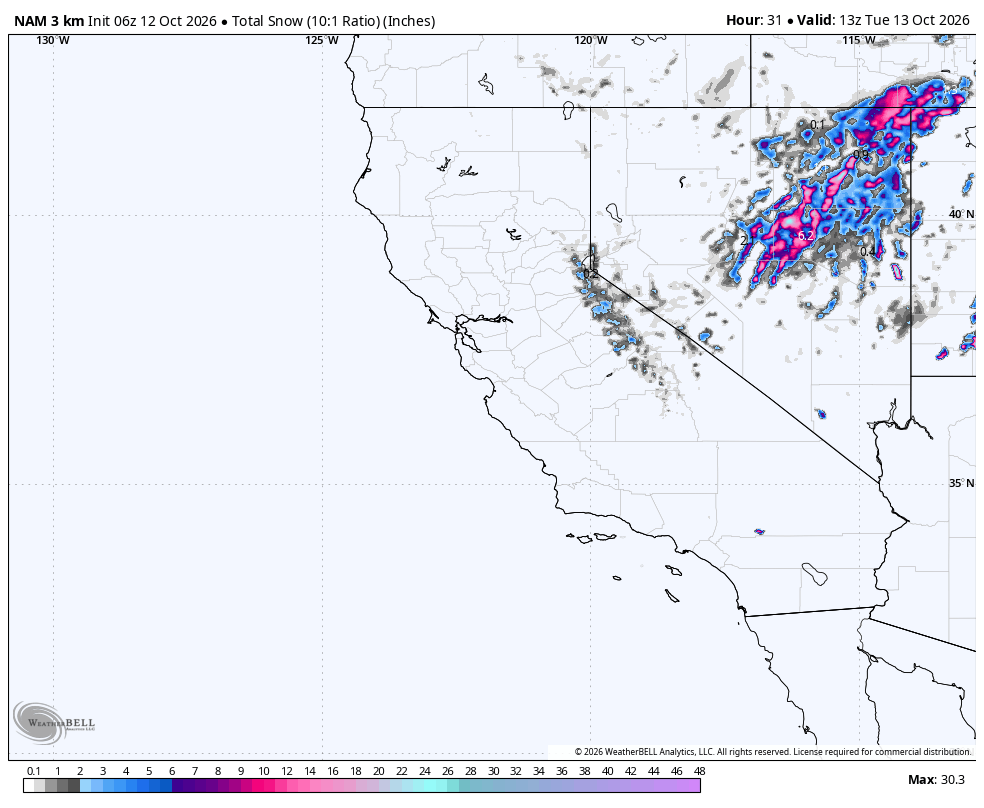
Initialized Oct 11, 11:00 PM PDT. Valid Oct 12, 12:00 AM PDT through Oct 14, 11:00 AM PDT. 60 source frames. Source: WeatherBell.
First, middle & last source frames
 First · Oct 12, 12:00 AM PDT ↗
 Last · Oct 14, 11:00 AM PDT ↗
NAM 3km 12-hour snow
Inches · fixed 10:1 ratio
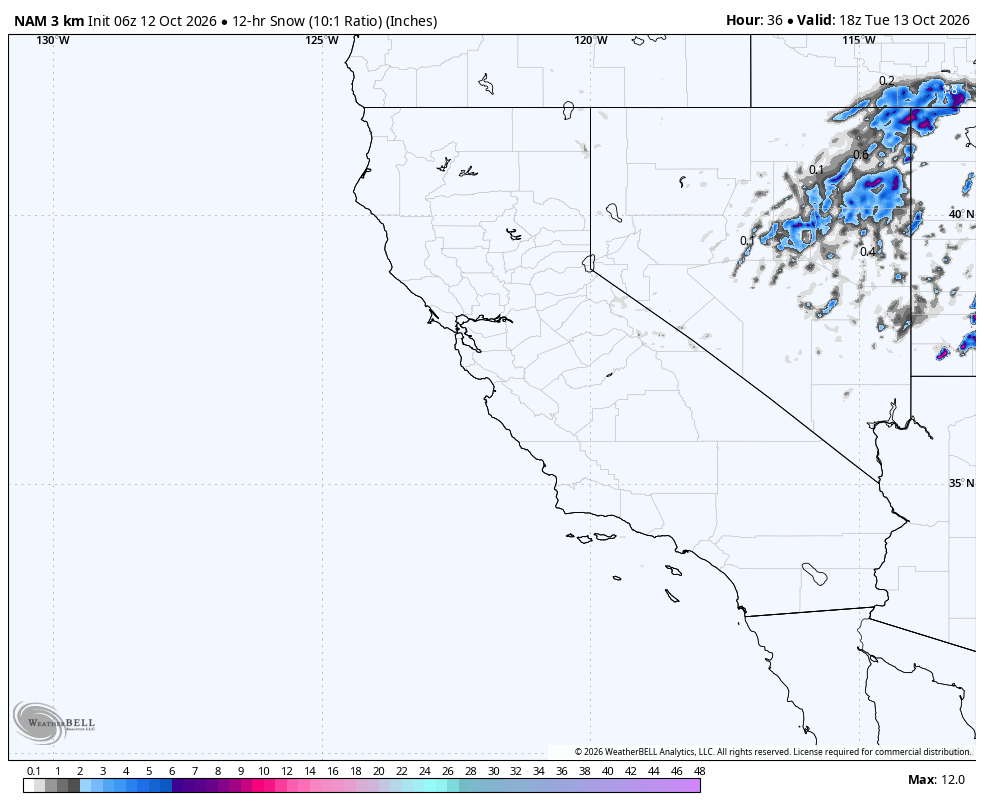
Initialized Oct 11, 11:00 PM PDT. Valid Oct 12, 11:00 AM PDT through Oct 14, 11:00 AM PDT. 49 source frames. Source: WeatherBell.
First, middle & last source frames
 First · Oct 12, 11:00 AM PDT ↗
 Last · Oct 14, 11:00 AM PDT ↗
RRFS Para v1 3km total snow
Inches · fixed 10:1 ratio

Initialized Oct 11, 11:00 PM PDT. Valid Oct 12, 12:00 AM PDT through Oct 15, 11:00 AM PDT. 84 source frames. Source: WeatherBell.
First, middle & last source frames
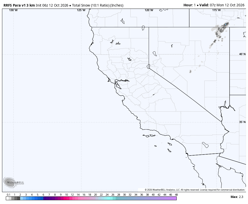 First · Oct 12, 12:00 AM PDT ↗
 Last · Oct 15, 11:00 AM PDT ↗
RRFS Para v1 3km 12-hour snow
Inches · fixed 10:1 ratio
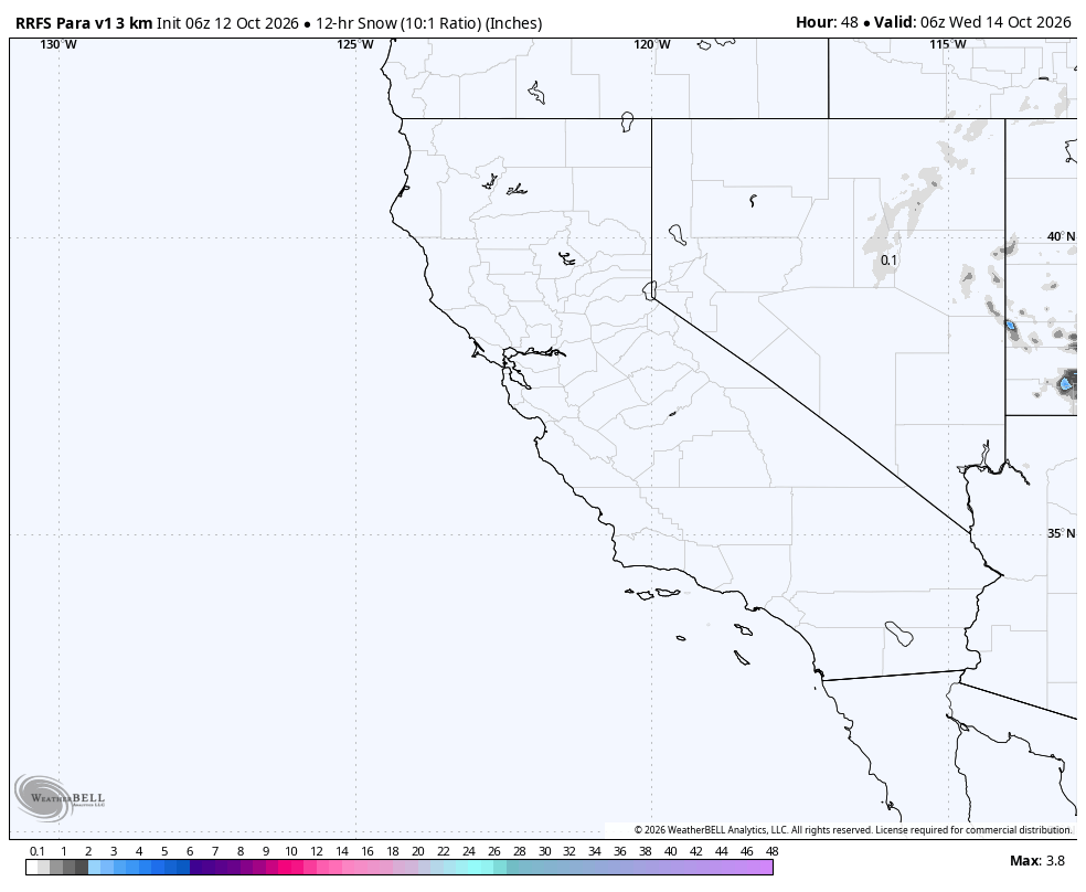
Initialized Oct 11, 11:00 PM PDT. Valid Oct 12, 11:00 AM PDT through Oct 15, 11:00 AM PDT. 73 source frames. Source: WeatherBell.
First, middle & last source frames
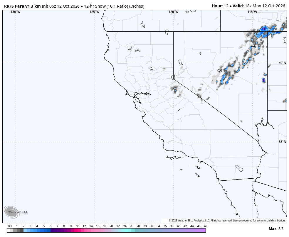 First · Oct 12, 11:00 AM PDT ↗
 Last · Oct 15, 11:00 AM PDT ↗
Official avalanche sources
Avalanche forecasts & advisories
Center-issued ratings, forecast periods and regional bulletins. These sources report avalanche problems by elevation and aspect. An unavailable or expired rating is not a Low rating.
Central Sierra Nevada
Sierra Avalanche Center
Off-season · no current dated rating
Checked Oct 12, 4:15 AM PDT. SAC is marked off-season; neither official map-layer feed supplies a current, dated danger rating. Consult the full official forecasts; missing is not Low danger.
Read the full avalanche forecast ↗Eastside Region
Eastern Sierra Avalanche Center
No current dated danger rating
Checked Oct 12, 4:15 AM PDT. SAC is marked off-season; neither official map-layer feed supplies a current, dated danger rating. Consult the full official forecasts; missing is not Low danger.
Read the full avalanche forecast ↗Live rating summaries: Avalanche.org / National Avalanche Center. Forecast coverage has boundaries. These cards do not replace the full center bulletin or observations along your route.
Avalanche sources checked October 12 at 4:12 AM PDT. Neither center supplied a current, dated danger rating.
Resort opening dates
2026/27 · First chair watch
Bull Wheels begin to spin.
Who spins first? Announced dates run earliest to latest. Dates can move with the snow and weather. Resorts without a confirmed date stay on the watch list below.
MammothMtn
Planned opening
Bull Wheels turn onNov 13, 202632 daysResort update ↗Last verified Oct 7 · current recheck unavailablePalisades Tahoe
Planned opening
Bull Wheels turn onNov 25, 202644 daysResort update ↗Last verified Oct 7 · current recheck unavailableSugar Bowl
Planned opening
Bull Wheels turn onNov 27, 202646 daysResort update ↗Resort snow report checked Oct 12 · target November 27KirkwoodMtn
Planned opening
Bull Wheels turn onDec 4, 202653 daysResort update ↗Last verified Oct 7 · current recheck unavailableMt. Rose
Awaiting resort confirmation
Bull Wheels turn onDate not confirmedDate pendingResort update ↗Source checked Oct 12; no confirmed opening date
Sugar Bowl’s November 27 target is confirmed in its October 10 snow-report check. MammothMtn, Palisades and KirkwoodMtn retain their October 7 date verification; fresh opening-date checks were unavailable. Mt. Rose has no confirmed date. Resort dates remain subject to change.
UC Berkeley · Donner Summit research station
Independent Snow Lab benchmark
Checked October 12, 2026. The current public portal did not expose a full observation date for its reading. No fresh daily measurement is asserted. The September 25 water-year 2026 benchmark below is historical; water year 2027 began October 1.
The Central Sierra Snow Lab gives us a university research record to read alongside resort reports and model guidance. One consistent observation site helps put Sierra storms and the season in perspective.
Water year 2026: October 1, 2025 to September 30, 2026. CSSL portal snapshot checked September 25, 2026 at 08:07 PDT.
Accumulated snowfall
306.7 inches
85% of the 1991–2020 median to date.
Median: 360.2 inches.
Rain + snow precipitation
58.7 inches of water
96% of the 1991–2020 median to date.
Median: 61.0 inches of water.
These are the lab’s displayed water-year-to-date values from the September 25 portal check, not final September 30 totals, winter 26/27 snowfall or a forecast. Snowfall and liquid precipitation measure different things. The latest manual observation time was not provided with the portal summary, so recent 24-hour, 48-hour and seven-day totals are not repeated here as verified observations.
Historical context & how to compare
The lab-published archive covers water years 1971–2025, excluding 2020, with snowfall, snow depth, snow water equivalent, precipitation and temperature. Missing values and trace snowfall retain their original meaning.
Compare the same measurement, location and reporting window. The lab’s current snowfall schedule is stated as 8 a.m. PST, with updates by 9 a.m. PST on snow days. It does not match this page’s 0600–0600 Pacific resort reporting target. A Donner Summit station is a regional reference, not a substitute for conditions at each resort.
For seasonal comparisons, retain the source’s 1991–2020 median and published methods. Water-year totals, settled snow depth and new snowfall are separate records.
A dated current temperature reading could not be verified from the public portal. Undated readings are not treated as current observations.
Source: UC Berkeley Central Sierra Snow Laboratory; historical dataset by Andrew Schwartz and Randall Osterhuber, updated October 1, 2025.
Recent snowfall · verified reporting periods
First snow & the season tally
Measured snowfall · unavailable reports stay blank, not zero. Forecast snow is in the separate forecast table.
Sources checked Oct 12, 4:08 AM PDT. NWS Reno discussion issued Oct 12, 12:58 AM PDT; Sacramento discussion issued Oct 11, 1:39 PM PDT. Each forecast and observation retains its own issue or reading time.
Reporting day: 0600–0600 Pacific, ending Oct 11, 2026 · 0600 PDT. All snowfall totals below are in inches.
| Mountain / measuring site | 24 hours 0600–0600 | 48 hours | Seven days | Season to date |
|---|---|---|---|---|
| KirkwoodMtnResort report (base readings) | — | — | — | — |
| Palisades TahoeThe Village | — | — | — | — |
| Sugar BowlSummit · 8,383 ft | — | — | — | — |
| MammothMtnMain Lodge | — | — | — | — |
| Mt. RoseResort report | — | — | — | — |
— = no verified total. Daily snowfall periods end at 0600 Pacific. Resort totals on other reporting schedules are listed below.
Report times & resort-reported totals
KirkwoodMtn: Report is not current. Resort snow-report time: Updated April 23, 2026 at 5:09 AM PDT.
Palisades Tahoe: Summer report; winter totals unavailable. Resort snow-report time: 2026-09-08T09:50:24-0700.
Sugar Bowl: Report is not current. Resort snow-report time: 04/05/2026 03:57 PM.
MammothMtn: Report is not current. Resort snow-report time: 2026-10-09T08:56:25-0700.
Mt. Rose: Source reachable; latest posted snow report July 20, 2026. Prior-season figures are not current snow measurements.. Resort snow-report time: not provided.
KirkwoodMtn observations · four instruments
KirkwoodMtn weather · peak to snowplots
Morning observations · not a continuously updating station feed. Each instrument keeps its own clock.
Stations checked Oct 12, 2026 · 0408 PDT · refreshed at 0430 and 1900 Pacific
Chair 6 peak · FT Tech wind
Observed Oct 12, 2026 · 0400 station clock
- Wind speed
- 12.5 mph
- Peak gust
- 17 mph
- Direction
- SW · 223°
Chair 6 ridge · weather station
Observed Oct 12, 2026 · 0400 station clock
- Wind speed
- 15.7 mph
- Peak gust
- 21.2 mph
- Direction
- SW · 231°
- Average direction
- SW · 220°
- Air temperature
- 26.2°F
- Humidity
- 83%
- Wet-bulb temperature
- 24.5°F
- Dew point
- 21.9°F
Hayflat Snowplot · 7,850 ft
Observed Oct 12, 2026 · 0405 station clock
—24-hour new snow
New-snow reading unavailable.
- Air temperature
- 32.8°F
- Humidity
- 74%
- Wet-bulb temperature
- 29.5°F
- Dew point
- 25.3°F
- Reported pressure
- 29.84 inHg
Whiskey Snowplot · 8,475 ft
Observed Oct 12, 2026 · 0405 station clock
—24-hour new snow
New-snow reading unavailable.
- Air temperature
- 30.4°F
- Humidity
- 74%
- Wet-bulb temperature
- 27.9°F
- Dew point
- 23.3°F
- Rain · 5-minute record
- 0 in
Snowplot totals follow the station’s reporting window; the 0600–0600 snow day is not yet confirmed. — = no usable reading.
Source: KirkwoodMtn weather stations
Regional ridge & buoy observations
Sierra Crest & Lake Tahoe Basin
Ridge winds & buoy observations
Saved station snapshot · individual observation dates are shown in every row. Older readings are labeled by age.
Temperature, dew point and wind from the NWS Reno remote-station network. Each instrument keeps its own reading and clock.
| Station | Air °F | Dew point °F | From | Wind mph | Gust mph |
|---|---|---|---|---|---|
| Slide MountainSLIDE · 9650.0 ft | 24.9Oct 12, 3:40 AM PDT | 24.8Oct 12, 3:40 AM PDT | SSWOct 12, 3:40 AM PDT | 4.1Oct 12, 3:40 AM PDT | 11.5Oct 12, 3:40 AM PDT |
| Palisades · SiberiaSIBSV · 8700.0 ft | 26.7Oct 12, 4:00 AM PDT | 24.3Oct 12, 4:00 AM PDT | NOct 12, 4:00 AM PDT | 0.2Oct 12, 4:00 AM PDT | 1.3Oct 12, 4:00 AM PDT |
| Alpine Meadows · Ward Mt.SUMAM · Elevation differs by source | 28.4Oct 12, 4:00 AM PDT | 25.1Oct 12, 4:00 AM PDT | NOct 12, 4:00 AM PDT | 0.2Oct 12, 4:00 AM PDT | 0.2Oct 12, 4:00 AM PDT |
| MammothMtn · Top of 3MTH23 · 10448.0 ft | 24.7Oct 12, 4:00 AM PDT | 24.5Oct 12, 4:00 AM PDT | Unavailable | Unavailable | Unavailable |
| MammothMtn · Top of 22MTH02 · 10100.0 ft | 28.7Oct 12, 4:00 AM PDT | 25.8Oct 12, 4:00 AM PDT | SSEOct 12, 4:00 AM PDT | 19.5Oct 12, 4:00 AM PDT | 28.7Oct 12, 4:00 AM PDT |
| Tahoe NE buoyJPL01 · 6233.0 ft | 45.1Oct 12, 3:00 AM PDT | 28.4Oct 12, 3:00 AM PDT | SSWOct 12, 3:00 AM PDT | 13.6Oct 12, 3:00 AM PDT | 34.9Oct 12, 3:00 AM PDT |
| Tahoe NW buoyJPL04 · 6233.0 ft | 43.9Oct 12, 3:00 AM PDT | 30.4Oct 12, 3:00 AM PDT | SSWOct 12, 3:00 AM PDT | 15.2Oct 12, 3:00 AM PDT | 21.5Oct 12, 3:00 AM PDT |
| Tahoe SE buoyJPL02 · 6233.0 ft | 45.0Oct 12, 3:00 AM PDT | 30.1Oct 12, 3:00 AM PDT | SOct 12, 3:00 AM PDT | 13.4Oct 12, 3:00 AM PDT | 21.3Oct 12, 3:00 AM PDT |
| Tahoe SW buoyJPL03 · 6233.0 ft | 43.7Oct 12, 3:00 AM PDT | 28.0Oct 12, 3:00 AM PDT | WOct 12, 3:00 AM PDT | 14.5Oct 12, 3:00 AM PDT | 20.1Oct 12, 3:00 AM PDT |
Snapshot checked October 12 at 4:11 AM PDT. Every field carries its own observation time. Wind converted from declared knots to mph. SUMAM elevation differs: NWS 8,643 ft; feed 8,399 ft. Missing fields remain unavailable.
Latest NWS remote observations ↗Open the live NWS station table
Eyes on the mountains
Five resorts. A live look.
Open a camera for the latest view supplied by the resort. Use its on-screen timestamp; a frozen image is not a current observation.
KirkwoodMtn
Cornice Cam
All official cameras ↗Palisades Tahoe / Alpine Meadows
Palisades resort camera
All official cameras ↗Sugar Bowl
Mid Mountain Lodge
MammothMtn
Main Lodge · 8,909 ft
All official cameras ↗Mt. Rose
Main Lodge
All official cameras ↗03 · Eyes out front
The Pacific. The storms. What’s next.
Long-range weather, El Niño, ARs and the winter storm track.
El Niño & ENSO · RONI replaces ONI
El Niño continues to strengthen. NOAA CPC’s October 8 discussion expects strong-to-very-strong conditions through January–March 2027, with more than an 83% chance of that persistence. For October–December, it gives an 83% chance of three-month RONI reaching at least +2.5°C. For Tahoe and KirkwoodMtn, storm tracks, temperatures and snow levels still decide the local outcome.
What changed: RONI versus ONI
ENSO means El Niño–Southern Oscillation, the connected pattern of Pacific Ocean temperatures and atmospheric circulation. NOAA adopted the Relative Oceanic Niño Index (RONI) in February 2026 for operational ENSO monitoring and prediction.
- ONI: a three-month average of how far sea-surface temperatures in the equatorial Pacific’s Niño 3.4 region depart from their historical average.
- RONI: subtracts the average temperature departure across the tropical oceans from the Niño 3.4 departure, adjusts the result to a comparable variability scale, and takes a three-month average. That helps separate ENSO’s regional signal from broader ocean warming.
Latest NOAA readings
- Three-month RONI: +1.7°C for July–September 2026 (+1.69°C in CPC’s data file), up from +1.4°C for June–August. The current table uses ERSSTv6; recent values are preliminary and may be revised.
- Weekly relative Niño 3.4: +2.4°C for the week centered October 7, the latest weekly entry available at this check.
- Traditional weekly Niño 3.4: +3.3°C for that same week. Neither weekly reading is the three-month ONI or RONI.
A strong El Niño does not tell us how much snow Tahoe will get. Storm tracks, temperatures and snow levels decide whether we see rain, snain or snow.
ENSO sources checked Oct 12, 4:15 AM PDT. Monthly discussion issued October 8; next scheduled discussion November 12. Weekly and seasonal observations keep their own periods.
NOAA CPC ENSO advisory ↗ · RONI history & method ↗ · Why NOAA adopted RONI ↗ · Weekly relative data ↗ · Traditional weekly data ↗
Coop’s long-range read
The Pacific and winter ahead
Days 1–7 · Colder showers, then warming
Showers increase this afternoon and diminish tonight. Most moisture leaves before the coldest air arrives. Regional pass amounts remain modest; Tahoe lake level has little or no accumulation in the NWS Reno discussion. Sunny weather returns Tuesday, followed by warmer afternoons.
October 17–21 and October 19–25
CPC’s October 11 outlook favors warmer-than-normal temperatures and below-normal precipitation across Northern California and western Nevada. Confidence is 4 out of 5 for both periods. These broad probabilities can contain individual cool or wet days.
October 24–November 6 · Weeks 3–4
CPC’s October 9 discussion favors warmth across much of the western and northern United States. It favors wetter-than-normal conditions across parts of California and the Great Basin toward the Lower Rio Grande Valley. That is a broad two-week probability, not a Tahoe snowfall amount or arrival date.
October · Updated monthly view
CPC’s September 30 update favors above-normal temperatures west of the Continental Divide, with the highest odds in California, western Nevada and southern Oregon. Below-normal precipitation is favored across nearly all of the West Coast and the northern and central Great Basin. Individual wet or cooler days can still occur.
Winter 2026/27 · The broader pattern
CPC’s September 17 seasonal outlook favors wetter-than-normal conditions across California during parts of winter. The October 8 ENSO discussion expects strong-to-very-strong El Niño conditions through January–March 2027. Storm temperatures and snow levels decide rain or POW locally; seasonal guidance cannot establish opening-day conditions.
CFSv2 · Current ensemble review
NOAA’s monthly and seasonal precipitation and temperature maps retain their own initialization and valid periods. Precipitation anomalies are mm/day and temperature anomalies are K, relative to 1991–2020. Current pressure anomaly guidance is unavailable.
Atmospheric rivers and large storms
CW3E’s current forecast resources were checked today. No Tahoe-specific AR rank is established in this edition. Compare the regional NWS forecast and current model moisture guidance; an atmospheric-river signal elsewhere is not a Tahoe snowfall forecast.
Reviewed October 12. Each source retains its actual issue and valid period. Anomaly means a departure from its stated reference average; QPF is liquid precipitation; MSLP is mean sea-level pressure.
CPC extended outlook · Weeks 3–4 · NOAA CFSv2 maps · CW3E updates
GOES-East · North America observations
Infrared satellite observations, not a forecast or seasonal diagnosis.
GOES-East [FULLDISK] 0.04° · North America
ABI Channel 13 brightness temperature · °C
![GOES-East [FULLDISK] 0.04° · North America · Observed Oct 11, 10:19 AM PDT through Oct 12, 2:59 AM PDT.](https://images.squarespace-cdn.com/content/6627bd7c18b72448db6dc807/6b1ad549-cdbc-42cc-9574-ee56719c4ddd/goes_east_20261012_Middle.png?content-type=image%2Fpng)
Observed Oct 11, 10:19 AM PDT through Oct 12, 2:59 AM PDT. 35 source frames. Source: WeatherBell.
First, middle & last source frames
![GOES-East [FULLDISK] 0.04° · North America · First · Oct 11, 10:19 AM PDT](https://images.squarespace-cdn.com/content/6627bd7c18b72448db6dc807/e92ab928-a013-48ed-b254-b49c01beeb72/goes_east_20261012_First.png?content-type=image%2Fpng) First · Oct 11, 10:19 AM PDT ↗
First · Oct 11, 10:19 AM PDT ↗![GOES-East [FULLDISK] 0.04° · North America · Last · Oct 12, 2:59 AM PDT](https://images.squarespace-cdn.com/content/6627bd7c18b72448db6dc807/6d01e23a-0f37-4f99-a7ff-5a4a73dbd931/goes_east_20261012_Last.png?content-type=image%2Fpng) Last · Oct 12, 2:59 AM PDT ↗
Last · Oct 12, 2:59 AM PDT ↗European model guidance · all maps
European model guidance
Latest verified source set first. Earlier maps and their dated interpretation are in the archive below.
Liquid precipitation, circulation and seasonal context retain their own source times. T850 is a pressure-level temperature, not a local snow level.
ECMWF AIFS ENS 15-day precipitation anomaly
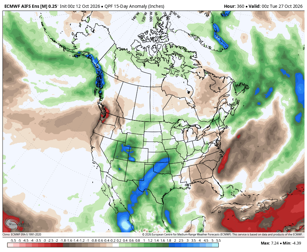
Single map. Initialized October 10 at 5:00 PM PDT (October 12 00Z); valid October 26 at 5:00 PM PDT (October 27 00Z). Liquid anomaly in inches relative to ERA5 1991–2020. Source: WeatherBell.
ECMWF AIFS ENS pressure, precipitation and T850
6-hour liquid precipitation · inches; MSLP · hPa; 850mb temperature · °C

Initialized Oct 11, 5:00 PM PDT. Valid Oct 11, 11:00 PM PDT through Oct 26, 5:00 PM PDT. 60 source frames. Source: WeatherBell.
First, middle & last source frames
 First · Oct 11, 11:00 PM PDT ↗
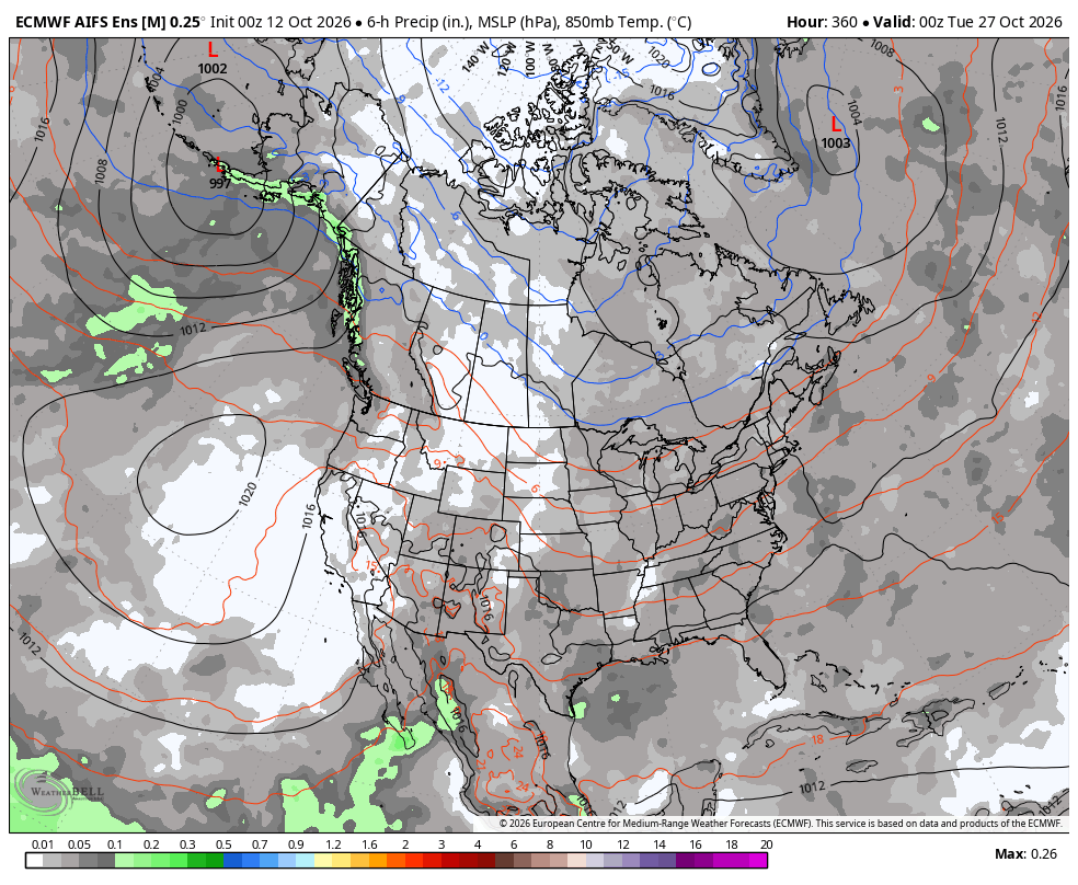 Last · Oct 26, 5:00 PM PDT ↗
ECMWF AIFS ENS five-day height anomaly
500mb height · dam; anomaly · meters; ERA5 1991–2020
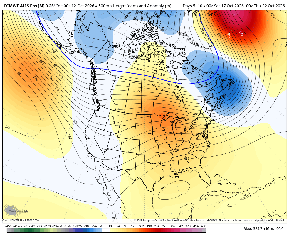
Initialized Oct 11, 5:00 PM PDT. Valid Oct 16, 5:00 PM PDT through Oct 26, 5:00 PM PDT. Each native header displays its complete five-day rolling window; still timestamps below are window ends. 41 source frames. Source: WeatherBell.
First, middle & last source frames
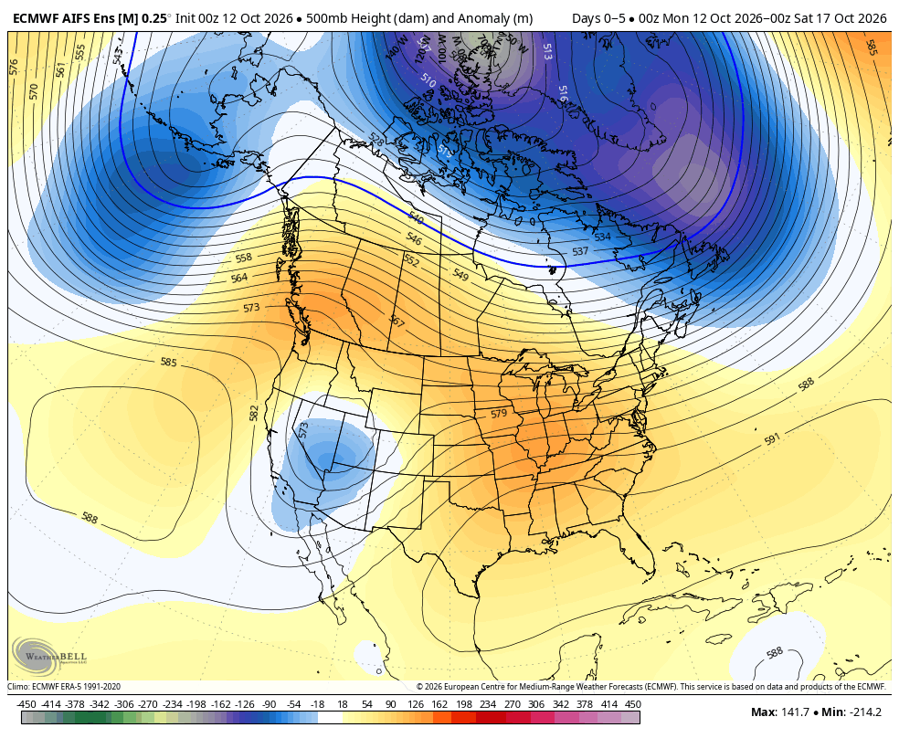 First · Oct 16, 5:00 PM PDT ↗
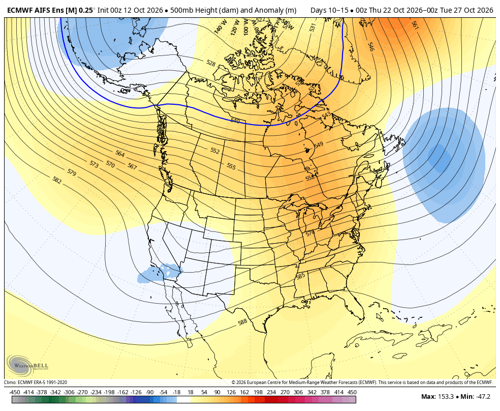 Last · Oct 26, 5:00 PM PDT ↗
ECMWF Seasonal monthly precipitation anomaly
Liquid anomaly · inches; source M-climate baseline

October 1, 2026 monthly issue. Monthly valid periods October 2026 through April 2027; not a daily reissue. 7 source frames. Source: WeatherBell.
First, middle & last source frames
 First · Sep 30, 5:00 PM PDT ↗
 Last · Mar 31, 5:00 PM PDT ↗
Extended & seasonal briefings
Extended and seasonal briefing
Use the October 11 briefing slides and European maps above. NOAA CPC outlooks retain their September 17 and 30 and October 8, 9 and 10 issue dates. The reviewed CFSv2 monthly and seasonal ensemble uses the initialization window printed on each current source map.
Current briefing graphics ↑ · Current European guidance ↑ · Official CFSv2 monthly and seasonal maps ↗
Play the extended & seasonal briefing

Know what the maps measure.
QPF anomaly
QPF is forecast precipitation measured as liquid water, including melted snow. An anomaly is the amount above or below a reference average. A monthly or seasonal inch anomaly is not a snowfall total.
MSLP anomaly
This is sea-level-adjusted air pressure compared with its reference average, in hPa. One hPa equals one millibar. It helps describe broad pressure patterns, not snow depth.
Ensembles & map spacing
An ensemble combines many possible forecasts. Agreement can build confidence, while disagreement widens the range. A 0.5° map helps show regional patterns, not individual Tahoe slopes.
Snow levels & storm confidence
Precipitation and cold air must arrive together. Local NWS guidance, elevation and the storm’s temperature profile matter more for the rain/snain/snow split than a single broad anomaly map.
Source notes: Shared NWS collection October 10 starting at 4:06 AM PDT. Reno discussion issued October 10 at 1:53 AM; Sacramento October 9 at 12:49 PM. Point forecasts, models and observations retain their own times. The October 1 ECMWF seasonal issue is current. Current resort snow measurements and dated avalanche ratings remain unavailable.
CPC extended outlook · CPC weeks 3–4 · CPC seasonal outlook · CW3E atmospheric river guidance
Coop’s read · Maps: WeatherBell / ECMWF.


Sierra Avalanche Center


